Why Are These Two Areas the Most Critical?
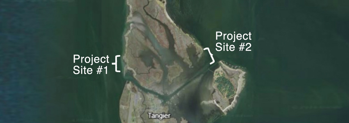
As you can see in Figure 1 at the top of the page, Projects 1 & 2 sit at opposite ends of the Tangier North Channel, which divides the island and provides access to the town. They are the two most extremely vulnerable areas of six critically endangered locations identified by the Accomack County Planning District Commission, county coastal planners, the Mayor, Tangier Town Council members, local scientists, local businesses and non-profit organizations as stakeholders.
Areas of Project 1 are losing 12 meters of land per year. It appears a tidal creek is forming which would compromise the western side of the channel.
Project 2 is losing over 13 meters of land per year. This area provides protection to Tangier harbor, the watermen’s soft crab processing facilities. It is a critical component of the town’s economy.
Protecting Tangier Island is just one of the benefits of these plans
The use of biogenic reefs delivers other attractive benefits to the island and its inhabitants:
• This proposed project will, in a matter of a few years, contain tens of millions of oysters, which represents a significant source of additional oyster larvae available to seed other oyster grounds in the region given the high fertilization efficiency associated with oysters living at such high density (thousands per square meter).
• Direct oyster fishery enhancement will improve water quality as well as the sustainability of various species that forage on oyster reefs or use them as nursery areas, which locally include striped bass, black sea bass, blue crabs, and red hake.
• Due to facilitation between oyster reefs and seagrasses, the restoration is also expected to increase the area of seagrass beds, which serve as critical nurseries and foraging grounds for numerous species.
• The vegetated and dune habitats will provide further ecosystem benefits and improved resilience to the local ecosystem and Tangier itself against further climate change impacts.
• The beach restoration is at a site that was formerly inhabited by the Federally threatened Northeastern Beach Tiger Beetle (Habroscelimorpha dorsalis), which would likely recolonize the site post-construction.
• Socioeconomic benefits of this project include employment of local residents in the construction, installation, and monitoring of the biogenic reefs; knowledge transfer and development of expertise in sustainable shoreline protection methods; potential business development in aquaculture and the installation of living shorelines; and empowerment of residents to control their environment by using cultural knowledge and expertise as well as new expertise acquired over the course of this project.
Dr. Russell Burke answered questions about the urgent need to begin work on both projects and what the significance of raising the needed funds would mean.
Project 1 – Western Entrance to Tangier Channel
X-Reefs and Atlantic Reefmaker reefs will provide offshore wave energy attenuation to protect the shoreline, and serve as oyster-fish reef habitat. Additional shoreline protection will be provided by longshore barrier reefs that will run the length of the shore NW of the existing rock jetty, and will be flanked by additional sediment control structures/reefs perpendicular to shore. Beneficially-reused/repurposed dredge material will be transported to backfill the area between the longshore/retention reefs and the receding marsh toe – the dredge material will then be covered by 6 to 12 inches of sand, capped with Flexamat for sediment retention, and planted with native marsh grasses.
Critical Issues and Vital Importance to Tangier
Answers provided by Dr. Russell Burke
What is the most dynamic or central element of this plan?
First and foremost, stabilizing the actively eroding shoreline at this project site is paramount – the concrete buttress reefs will support the sediment-filled GeoTubes, and the Flexamat will ensure containment of the backfilled sand/sediment, along with the planted marsh grasses.
How important is it to reach or exceed the goal of $2.5 million for Project 1?
It is critical that the project receive the requisite funding to procure and install the reinforcing elements of the project design which will stabilize the wetlands at this site, including the placement of sand and/or dredged sediment.
How soon can work begin?
With funding in hand, we could submit the permit application, receive approval, and begin reef fabrication and project material procurement this spring (2027), with construction on site starting later next summer.
What is the benefit of using natural and nature-based features in this project?
The principal benefits of using natural and nature-based features are (1) nature is able to recover to its previous, undamaged state much faster, and (2) the design is intended to promote the long-term sustainability of oyster and fish reef habitats and reduce future maintenance requirements.
What is the significance of this campaign’s success?
The significance of this campaign’s success is (1) the immediate protection of this portion of Tangier Island and (2) this project will serve as a template for how to preserve, protect, and restore the rest of Tangier Island where marshlands are eroding and land continues to be lost.
Project 2 – Eastern Entrance to Tangier Channel
Site 2 is a rapidly disappearing peninsula. This area provides protection to Tangier Harbor and the watermen’s soft-shell crab processing facilities, a critical component of the Town’s economy. The peninsula has lost approximately 558 feet of length since 2011, a rate of over 43 feet/year. At present, this remnant peninsula no longer provides significant protection to Tangier’s harbor and facilities. In addition, much of the sediment that erodes ends up contributing to the buildup of sediment which can block Tangier’s channel. Restoring the peninsula provides Tangier with two important benefits.
Critical Issues and Vital Importance to Tangier
Answers provided by Dr. Russell Burke
What is the most dynamic or central element of this plan?
The central element of this plan is wave attenuation (reduction) via concrete reef breakwaters. The precise design reduces the wave energy reaching the wetlands located inshore of the project site and protects the town’s infrastructure on the eastern side of Tangier Island. The secondary benefits will be increased resident oyster/mussel communities on the reefs, and the provision of habitat and food for local fish and crabs
How important is it to reach or exceed the goal of $3.25 million for Project 2?
In order to protect existing wetlands inshore of this project site, offshore reef breakwaters need to be fabricated and installed. Reaching (or exceeding) the fundraising goal is essential for the success of this project due to the large size of the area exposed to wind-generated waves, and the critical town infrastructure currently vulnerable to them during storms.
How soon can work begin?
With funding in hand, we could submit the permit application, receive approval, and begin reef fabrication and project material procurement this spring (2027), with construction on site starting later next summer.
What is the benefit of using natural and nature-based features in this project?
The principal benefits of using natural and nature-based features are (1) wetland and adjacent upland environments will be able to maintain themselves under a reduced wave energy regime, and (2) the design is intended to promote the long-term sustainability of wetland habitats and reduce future maintenance requirements.
What is the significance of this campaign’s success?
The significance of this campaign’s success is (1) the immediate protection of this portion of Tangier Island and (2) this project will serve as a template for how to preserve, protect, and restore the rest of Tangier Island while enhancing local fisheries.